The strongest and deadliest earthquakes — and how magnitude really works
Magnitude measures the energy released at the fault; intensity measures the shaking where you stand. Whether people die depends mostly on neither — it depends on what they are standing in, and at what hour.
In 2010 two earthquakes struck the Americas six weeks apart. The one in Chile released roughly 500 times more energy than the one in Haiti. Chile lost about 525 people; Haiti lost somewhere between 46,000 and 316,000. Explaining that gap takes two numbers the news tends to blur into one, and a short list of the planet's worst days.
Magnitude and intensity are two different numbers
An earthquake has one magnitude. It is a property of the source: how large an area of fault slipped, by how much, and how stiff the rock was. It does not change depending on where you are.
An earthquake has many intensities. Intensity describes what the shaking did at a particular place — whether people woke up, plaster cracked or buildings came down. The US uses the Modified Mercalli scale, in Roman numerals from I (not felt) to XII; Russia uses the similar 12-degree MSK-64 scale. Intensity falls off with distance and depth, rises on soft sediment, and depends on how local buildings respond.
A magnitude 7.0 under a city and a 7.0 two hundred kilometres offshore are the same earthquake and entirely different disasters. The simulator draws exactly this: pick a magnitude and it draws intensity rings, from V (clearly felt) to IX and above (buildings collapse); then the building quality you choose decides how many people inside those rings die.
What the Richter scale is, and how it works
In 1935 Charles Richter, at Caltech, rated Southern California earthquakes by the amplitude of the trace they left on a particular seismograph, corrected for distance. His local magnitude only held for California quakes within about 600 km of that instrument, but the idea — a logarithmic number for the size of an earthquake — became the most famous scale in science.
How it works: each whole number up means ten times the wave amplitude on the seismogram and, more importantly, about 32 times more energy. Two steps is 32 × 32, roughly a thousand times. A magnitude 8 is not twice a magnitude 4; it releases about a million times more energy.
The Richter scale's weakness is that it saturates: past about magnitude 7 the waves it measured stop growing, so every great earthquake looked much the same. In 1979 Tom Hanks and Hiroo Kanamori introduced the moment magnitude scale (Mw), calculated from the rupture itself: rock rigidity × fault area that slipped × average slip. It was tuned to match Richter's numbers where both work, which is why the news still says "on the Richter scale". The magnitudes published for large earthquakes today, including every one in this article, are moment magnitudes.
What is the range of the Richter scale? Formally it has no top or bottom. Tiny earthquakes can have magnitudes below zero; anything under about 2 is rarely felt. The top is set by the Earth, not the formula: the largest ever measured is 9.5.
How often each magnitude happens
Each step up in magnitude is roughly ten times rarer. The USGS estimates about 500,000 detectable earthquakes a year, of which about 100,000 are felt and about 100 cause damage.
| Magnitude | Energy at the low end (TNT) | Per year worldwide | What it typically means |
|---|---|---|---|
| 5.0–5.9 | ≈ 0.5 kt | ≈ 1,600 | Damage to weak buildings close to the epicentre |
| 6.0–6.9 | ≈ 15 kt | ≈ 137 | Destructive in a populated area; Northridge, Kobe, Spitak |
| 7.0–7.9 | ≈ 480 kt | ≈ 14 | Major: serious damage over wide areas; Haiti, Turkey 2023 |
| 8.0 and up | ≈ 15 Mt | ≈ 1 | Great: whole regions affected, often a tsunami |
Counts are USGS worldwide averages for 2000–2021 (the long-term average since 1900 is about 15 magnitude-7 events and one magnitude 8 a year); individual years vary widely, from 6 to 23 magnitude-7 events and from 0 to 4 magnitude-8 events.
The strongest earthquakes ever recorded
All of the largest earthquakes on record happened on subduction zones, where one plate dives beneath another along a fault hundreds of kilometres long. Only these megathrusts have enough fault area to reach magnitude 9.
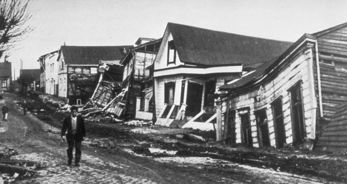
Valdivia, Chile, 22 May 1960 — magnitude 9.5
The biggest earthquake ever recorded ruptured a fault the USGS describes as almost 1,000 miles (1,600 km) long. The accepted figure is 9.5; published estimates run from about 9.4 to 9.6. It killed about 1,655 people in southern Chile by the USGS count (estimates range from 1,000 to 6,000), left some 2 million homeless, and sent a tsunami that killed people in Hawaii and Japan the next day. Because the scale is logarithmic, Valdivia alone released about as much energy as the next four on the list combined.
Alaska 1964, Sumatra 2004, Tōhoku 2011
The Great Alaska earthquake of 27 March 1964 (9.2) is the largest in US history; most of its 131 deaths were caused by tsunamis, many of them local waves from underwater landslides. The Sumatra–Andaman earthquake of 26 December 2004 is usually given as 9.1 (some estimates reach 9.3); its tsunami killed about 227,900 people. The Tōhoku earthquake of 11 March 2011 is 9.0 in Japan's catalogue and 9.1 in the USGS's; about 18,500 people died or went missing, nearly all in the tsunami. All three waves are covered in the deadliest tsunamis in history.
Kamchatka, 1952 and 2025
The Kuril–Kamchatka trench, where the Pacific plate dives beneath the North American plate at about 8 cm a year, produced a magnitude 9.0 on 4 November 1952. Its tsunami wiped out Severo-Kurilsk on Paramushir Island before dawn; a report to Moscow counted 2,336 dead, and the disaster stayed secret for decades. On 30 July 2025 (29 July UTC) the same zone produced a magnitude 8.8 about 119 km from Petropavlovsk-Kamchatsky — the largest earthquake anywhere since Tōhoku, ten days after a 7.4 foreshock. Its tsunami flooded the port of Severo-Kurilsk again, but no deaths from the shaking or the waves were reported. At 0.2 smaller, it released about half the energy of 1952.
Is a magnitude 10 earthquake possible? And the "9.9" myth
Videos and posts about a "9.9 earthquake, the biggest in the world" describe something that never happened. No 9.9 has ever been recorded; Valdivia's 9.5 has held the record for more than six decades.
A magnitude 10 is forbidden not by the formula but by the planet. Magnitude scales with the area of fault that slips, and the USGS says plainly that magnitude 10 earthquakes cannot happen: no fault long enough is known, and one would have to extend around most of the planet. A 10 would release about 5.6 times Valdivia's energy. Large asteroid impacts can shake the ground harder, but they are not earthquakes; see what a meteor does, size by size.
The deadliest earthquakes in history
Rank earthquakes by deaths instead of magnitude and the list changes almost completely. Only one event — Sumatra 2004 — appears on both.
Shaanxi, 1556 — about 830,000 dead
On 23 January 1556 an earthquake of estimated magnitude around 8 struck the Wei River valley in northern China. The death toll, drawn from Chinese historical records, is about 830,000 — still the highest of any earthquake. Many victims lived in yaodong, cave homes dug into cliffs of soft loess, which collapsed onto the people inside.
Tangshan, 1976 — 242,000 by the official count
At 3:42 in the morning on 28 July 1976 a magnitude 7.5 earthquake hit directly beneath Tangshan, an industrial city of about a million people. Almost everyone was asleep in unreinforced brick buildings, and the city was all but levelled. The official toll is about 242,000; unofficial estimates run considerably higher, and the true number is not known.
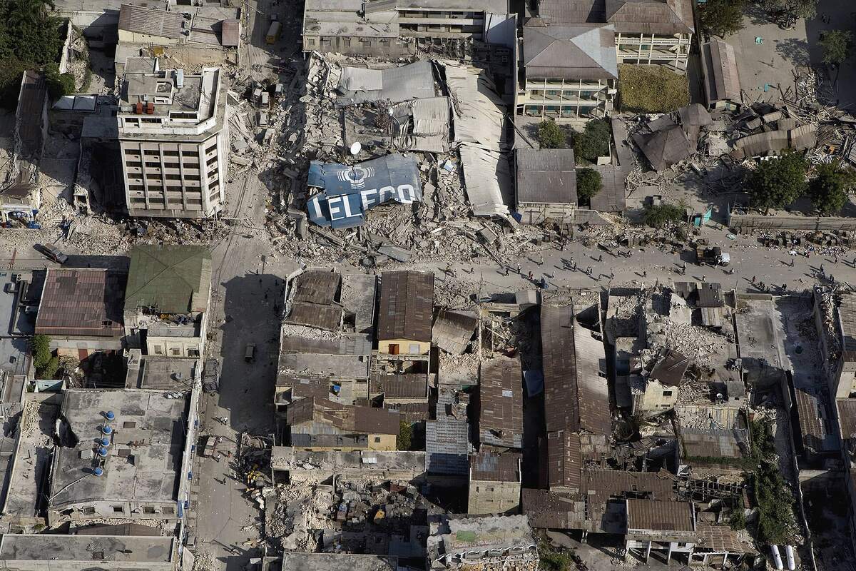
Haiti, 2010 — why the range is so wide
The magnitude 7.0 earthquake of 12 January 2010 struck at 4:53 pm, about 25 km from Port-au-Prince, a crowded capital of unreinforced and poorly made concrete. A year later Haiti's government put the toll at 316,000. Independent household surveys found far fewer — from about 46,000–85,000 to roughly 160,000, depending on the team. The gap exists because the state itself was crippled (the national palace, parliament building and many ministries collapsed) and many victims went into mass graves uncounted.
Kantō 1923, Messina 1908, Turkey–Syria 2023
The Great Kantō earthquake hit Tokyo and Yokohama at 11:58 am on 1 September 1923, as stoves were lit for lunch in cities of wooden houses; wind-driven fires killed most of the roughly 105,000 victims (older figures say 142,000). The Messina earthquake struck before dawn on 28 December 1908, followed within minutes by a tsunami; 75,000–82,000 died, the worst toll in European history. The Kahramanmaraş earthquakes of 6 February 2023 — a 7.8 at 4:17 am and a 7.5 nine hours later — brought down tens of thousands of buildings in Turkey and Syria, killing more than 59,000 people by official counts.
Put a Kantō-sized magnitude 7.9 under today's Tokyo, built to modern codes →Why death tolls follow buildings, not magnitude
Put the two lists side by side and the pattern is obvious. Chile, 27 February 2010, magnitude 8.8: it struck at 3:34 am, when people were in bed, and killed about 525 people, many of them in the tsunami that followed. Haiti, six weeks earlier, magnitude 7.0: roughly 500 times less energy, and a death toll one or two orders of magnitude higher. Chile rebuilt after 1960 under some of the world's strictest seismic codes, and enforces them. Haiti had no enforced national building code.
Run a magnitude 8.8 under Santiago with modern codes →That is why the simulator asks how the city is built. A well-designed reinforced frame cracks but stays up; unreinforced masonry, heavy roofs on weak walls and badly detailed concrete fail at intensities modern buildings survive.
The hour matters too
Time of day decides who is inside what. Tangshan (3:42 am) and Turkey (4:17 am) caught people asleep in buildings that fell. Northridge struck Los Angeles at 4:31 am on a public holiday, when the freeway bridges that collapsed were nearly empty. But time is the smaller factor: Chile's 8.8 also hit at night and killed a fraction of Haiti's afternoon toll.
Spitak and Neftegorsk: the Soviet lesson
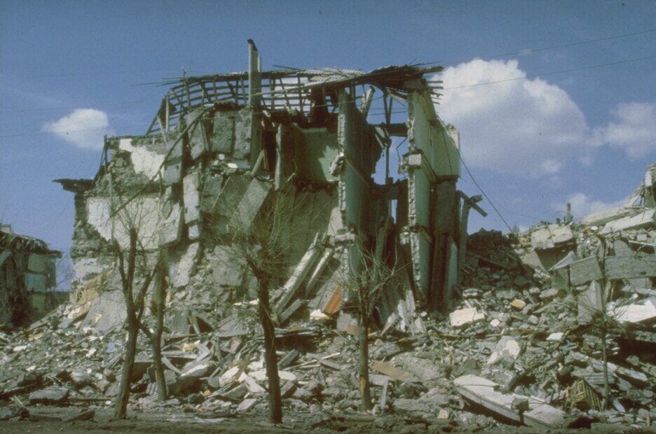
On 7 December 1988 at 11:41 am a magnitude 6.8 earthquake — moderate by global standards — struck northern Armenia. Intensity reached 10 on the MSK scale at Spitak and 9 in Leninakan (now Gyumri). About 25,000 people died and more than half a million lost their homes, largely because precast concrete apartment blocks, with floors poorly tied to their frames, came apart.
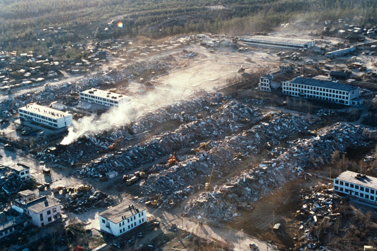
Seven years later, at 1:04 am on 28 May 1995 (local time), a magnitude 7.0–7.1 earthquake destroyed Neftegorsk, an oil town on Sakhalin. Its seventeen five-storey panel blocks were not designed for strong shaking — the Soviet hazard map had badly underrated the area — and they collapsed on sleeping residents. About 2,000 people died (sources give 1,989 to 2,040) — at least half the town. The town was never rebuilt; it remains the deadliest earthquake in modern Russia.
The biggest earthquakes in California
California sits on the San Andreas system, where the Pacific and North American plates slide past each other. Such faults cannot produce a magnitude 9, but they produce very destructive 7s.
- Fort Tejon, 9 January 1857 — magnitude 7.9. Tied with 1906 as California's biggest. It broke about 300 km of the San Andreas, from near Parkfield almost to Wrightwood, with up to 9 m of offset; the state was so thinly settled that one or two people died.
- San Francisco, 18 April 1906 — magnitude 7.9. A longer rupture, from San Juan Bautista to Cape Mendocino. Early reports gave a few hundred deaths; research by Gladys Hansen and Emmet Condon puts the toll above 3,000. Fires burned for three days across 4.7 square miles.
- Loma Prieta, 17 October 1989 — magnitude 6.9. It hit at 5:04 pm, just before a World Series game at Candlestick Park. Of 63 deaths, 42 came when the upper deck of Oakland's Cypress Street Viaduct fell onto the lower one.
- Northridge, 17 January 1994 — magnitude 6.7. A hidden thrust fault under the San Fernando Valley; at least 57 dead, collapsed freeways, and cracked steel-frame connections that led to code changes.
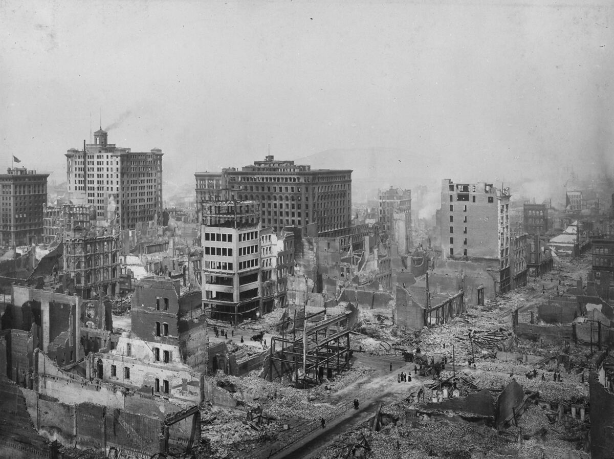
A repeat of 1906 would hit a Bay Area of millions, mostly built to modern codes but with many older masonry and soft-story buildings. Try it, then switch the building quality and watch the estimated toll change. To see what visitors have simulated in the last 30 days, look at recent simulations.
Replay the 1906 magnitude 7.9 on today's San Francisco →FAQ
What is the Richter scale and how does it work?
Created by Charles Richter in 1935, it rates an earthquake by the amplitude of its waves on a seismograph, adjusted for distance. Each whole number is ten times the amplitude and about 32 times the energy. Because it saturates for big earthquakes, seismologists now use moment magnitude, which gives similar numbers in the moderate range.
What is the biggest earthquake ever recorded?
The magnitude 9.5 earthquake near Valdivia, Chile, on 22 May 1960. Next come Alaska 1964 (9.2), Sumatra 2004 and Tōhoku 2011 (both 9.1 by the USGS) and Kamchatka 1952 (9.0). The largest since 2011 is the 8.8 off Kamchatka on 30 July 2025.
Was there ever a 9.9 earthquake?
No. No earthquake of magnitude 9.9 has ever been recorded; claims about one are a myth. The largest ever measured is 9.5, in Chile in 1960.
Is a magnitude 10 earthquake possible?
Practically, no. Magnitude depends on the area of fault that slips, and according to the USGS no known fault is long enough to produce a magnitude 10 — such a fault would have to extend around most of the planet. A 10 would release about 5.6 times the energy of the record 9.5.
What was the deadliest earthquake in history?
The Shaanxi earthquake in China on 23 January 1556, which killed about 830,000 people. In modern times the worst were Tangshan, China, 1976 (242,000 officially), the 2004 Indian Ocean earthquake and tsunami (about 227,900) and Haiti 2010 (estimates from 46,000 to 316,000).
What was the biggest earthquake in California?
Two earthquakes share the title at magnitude 7.9: Fort Tejon in 1857 and San Francisco in 1906. The 1906 quake killed more than 3,000 people; Fort Tejon, in a nearly empty California, killed one or two. The most damaging recent ones were Loma Prieta 1989 (6.9) and Northridge 1994 (6.7).
Sources
- USGS — Earthquake magnitude, energy release, and shaking intensity
- USGS — 10 largest earthquakes ever recorded (updated 2025)
- USGS — 20 largest earthquakes in the world since 1900
- USGS — Can "megaquakes" really happen, like a magnitude 10 or larger?
- USGS — Earthquake lists, maps and statistics (annual worldwide counts)
- USGS — Cool earthquake facts
- USGS — M 8.8, 2025 Kamchatka Peninsula, Russia earthquake
- USGS — M 8.8, 2010 Maule, Chile earthquake: impact
- USGS — The 1964 Great Alaska earthquake and tsunamis: a modern perspective and enduring legacies
- NOAA NCEI — Global Significant Earthquake Database
- Doocy et al., Population Health Metrics (2013) — Mortality following the Haitian earthquake of 2010: a stratified cluster survey
- NOAA NCEI — The Spitak earthquake
- USGS — M7.9 1857 Fort Tejon earthquake
- USGS — Casualties and damage after the 1906 earthquake
- USGS — M6.7 January 17, 1994 Northridge, California earthquake