Real events · Earthquake · 22 October 2026
Mw 7.0 Baqên County earthquake, Nagqu, Tibet: October 2026 review
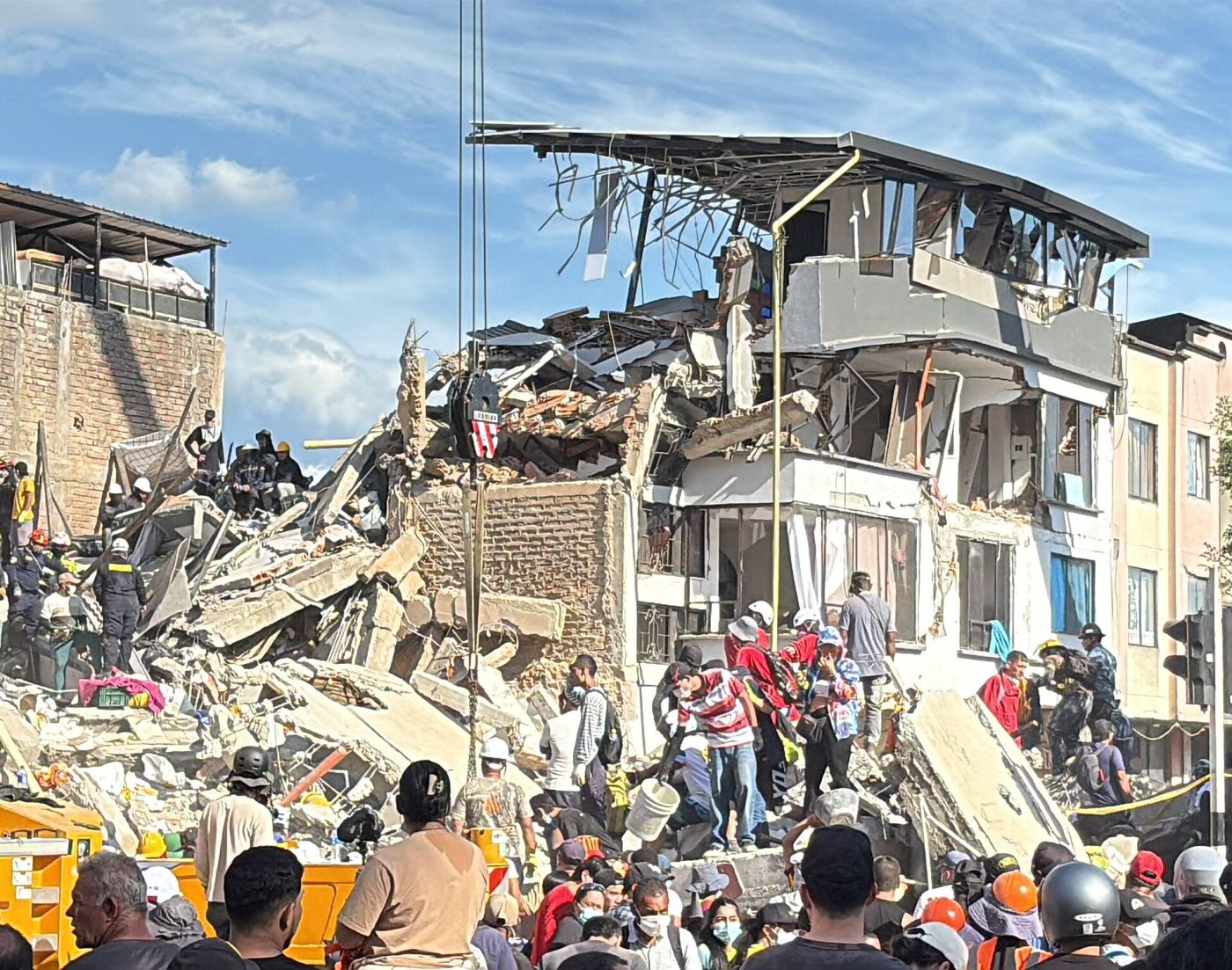
Photo: World Central Kitchen, CC BY 4.0, Wikimedia Commons
A shallow magnitude 7.0 earthquake struck a high, thinly populated corner of northern Tibet late on 22 October 2026. As of 23 October, 16 people had died, 76 were injured and more than 12,000 residents had been moved to safety.
Key facts
- Time
- 22 October 2026, 14:33 UTC
- Magnitude
- 7.0 (mww)
- Depth
- 18.0 km
- Tsunami
- none
- Alert level
- PAGER: orange
- Coordinates
- 32.34, 93.71
- Source
- USGS
What happened in Baqên County on 22 October
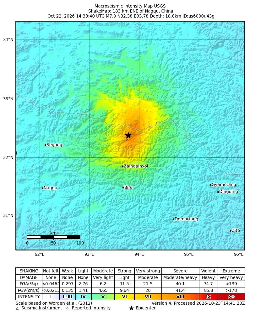
At 14:33 UTC on 22 October 2026, 22:33 Beijing time, a magnitude 7.0 earthquake struck Maru Township in Baqên (Baqen) County, part of Nagqu City in northern Tibet (Xizang), near the border with Qinghai. The USGS reviewed the event as Mww 7.0 at a depth of 18 km, centred at 32.380°N 93.780°E, about 191 km east-northeast of Nagqu.
China's earthquake network (CENC) agreed on the magnitude but not quite on the location or depth. According to Xinhua, CENC placed the epicentre at 32.40°N 93.79°E with a depth of 10 km. Differences of this size between agencies are normal in the first days after a large quake, and both solutions describe a shallow event in the upper crust.
The USGS recorded at least seven aftershocks between magnitude 4.3 and 5.2. Because the epicentre lies far inland, there was no tsunami risk. Reuters described it as the strongest earthquake to hit China since January 2024, and CCTV called it the biggest in the region in five years.
Casualties and damage: the numbers so far
The death toll has stayed at 16 through every official update. The injury count has climbed as reports came in from remote townships. The first AP report, citing the Nagqu media office, gave 32 injured. Early on 23 October the Nagqu emergency management bureau reported 46, and Xinhua gave 54 as of 7 a.m. that day. Later updates put the figure at 65, then 76.
The most complete picture so far came from the Nagqu municipal government at a press conference on 23 October, with figures as of 13:00 local time, as reported by The Watchers:
- 16 people dead
- 76 injured, 11 of them seriously
- homes of 339 households collapsed or damaged
- 20 livestock enclosures affected
- 12,489 residents relocated to safer places (as of 10:00)
No official figure for missing people had been published by 23 October, and the damage assessment was still under way. All of these numbers should be read as provisional.
Aerial reconnaissance found damaged buildings within 20 km of the epicentre. Maru and Gangqie townships were among the worst affected, with badly damaged earthen walls, partly collapsed brick buildings and ground cracks near Maru. That pattern fits what the USGS PAGER system flagged: the most common vulnerable buildings in the region are adobe block and unreinforced brick with mud.
Why this part of Tibet shakes
The Tibetan Plateau was raised by the collision of India with Eurasia. It is now so high that it spreads east and west under its own weight. That stretching is taken up largely by strike-slip and normal faults, and the USGS found that this quake was caused by normal faulting on a crustal fault dipping moderately either northwest or southeast. A typical rupture for an event of this size measures about 50 km by 20 km.
The USGS also points out that this part of the plateau has few people, so damage from a large earthquake depends heavily on how close the rupture runs to settlements. PAGER issued a yellow alert for fatalities and an orange alert for economic losses, estimated at under 1% of China's GDP. Its ground-failure product suggested a significant area of possible landslides, though with little exposed population.
How it compares with other Tibetan earthquakes
Earthquakes of magnitude 7.0 or more are rare in Tibet: about nine since 1900, according to a Reuters factbox. The closest recent parallel is the Mw 7.1 Tingri earthquake of 7 January 2025 in southern Tibet, also a normal-faulting event. It killed 126 people according to the official toll and destroyed about 3,600 homes. On the figures available as of 23 October, the Nagqu quake has caused far fewer losses.
Further back, the M8.0 Damxung earthquake of 1951 remains one of the largest in the region's record. An M6.6 event near Damxung in 2008 killed at least 10 people, and an M5.9 shock in Nagqu in June 2024 caused no reported casualties. About 272 km to the east-northeast, the M6.9 Yushu earthquake in Qinghai on 14 April 2010 killed more than 2,500 people, which shows how much depends on where the strongest shaking falls.
What our simulator shows
HazardSim models simple circular zones of expected shaking around the event point and counts the people living in towns mapped in OpenStreetMap inside each zone. For this event we used radii of 20 km for intensity 8, 46 km for intensity 7 and 94 km for intensity 6. Our model ran on the initial location (32.3357, 93.7138), which the USGS has since refined by a few kilometres.
The result was zero people in all three zones. That figure is wrong as a measure of real exposure, and we want to be plain about it. Officials relocated 12,489 residents and reported damage in Maru and Gangqie townships, well inside our modelled zones. The most likely cause is sparse OpenStreetMap coverage of small herder settlements on the plateau, where many communities are not mapped as towns at all. Our model is deliberately simplified: it ignores fault geometry, local soils and building types, and it can only count people the map knows about. Here, the map knew about almost nobody.
Relief at altitude and in the cold
China raised its national earthquake emergency response from Level IV to Level III, and the China Earthquake Administration ran a Level II response. According to CGTN and The Watchers, responders included more than 1,600 people organised by Baqên County, over 300 police officers, about 350 fire-and-rescue staff and 262 members of the People's Armed Police. A Wing Loong drone was sent for aerial assessment, and State Grid had restored power to 1,937 households by 10:00 on 23 October.
Supplies sent to the area included 1,000 prefabricated housing units, 3,239 tents, 2,821 folding beds and 4,280 quilts. ThePrint reported that 50 million yuan was allocated for emergency relief, with another 30 million yuan set aside for recovery.
Access has been difficult. Rockfalls closed part of National Highway 317 to all but emergency and official vehicles, trains through the zone were stopped, and communications failed in places, as reported by Dimsum Daily. The epicentral area sits above 4,800 m on average. Xinhua reported forecasts of temperatures falling to −9 °C over three days, with intermittent snow expected in three townships near the epicentre. For thousands of people now sleeping in tents and temporary shelters, the weather will shape the coming week as much as the earthquake itself.
What the simulator shows
The simulator turns magnitude and depth into shaking intensity on the Modified Mercalli scale. By that estimate intensity VI, at which loose objects fall from shelves, reaches 94 km from the epicentre, and no town listed in GeoNames lies inside that circle.
This is a simplified model, not a damage report. Real effects depend on soil, buildings, terrain and the details of the event.
Open in the simulatorSources
- Official data: USGS
- GeoNames (CC BY 4.0): geonames.org
- USGS: M 7.0 - 191 km ENE of Nagqu, China (event page, executive summary)
- Xinhua: Update: 7.0-magnitude quake hits SW China's Xizang: CENC
- Xinhua: 16 killed, 54 injured after 7.0-magnitude quake hits China's Xizang
- CGTN: 16 killed after M7.0 quake hits China's Xizang, rescue efforts underway
- The Watchers: M7.0 earthquake kills at least 16, injures 76 in Xizang, China
- The Watchers: Strong and shallow M7.0 earthquake hits Xizang-Qinghai border region, China
- NBC News / Associated Press: A 7.0 earthquake hits China's Tibet, killing 16 and injuring 32
- ThePrint (PTI): 16 killed, 76 injured as magnitude 7 quake hits Tibet; over 12,000 evacuated
- Dimsum Daily: Tibet quake kills at least 16 in Baqen County
- Al Jazeera: Powerful earthquake in Tibet kills at least 16 people
This review was compiled with AI assistance from the sources listed below and checked against official data.
More recent events
Click a point to open the event
 M6.3Magnitude 6.3 earthquake: Torres Islands, Vanuatu
 M6.0Magnitude 6.0 earthquake: Torres Islands region, Vanuatu
 M6.9Magnitude 6.9 earthquake: Kamchatka Peninsula, Russia
 296 km/hReviewSuper Typhoon Champi: the 10-mile miss south of Guam
 M6.0Magnitude 6.0 earthquake: New Britain region, Papua New Guinea
 M6.8Magnitude 6.8 earthquake: Central Mid-Atlantic Ridge