Real events · Earthquake · 9 October 2026
Panama M7.7 earthquake on the Azuero Peninsula, 9 October 2026
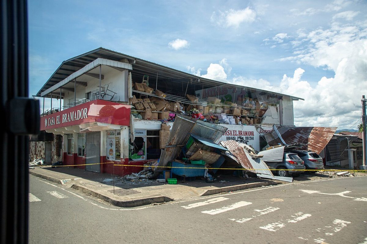
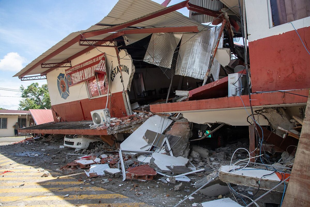
Photo: U.S. Army photo by Pfc. Carolyn Dodge, Public domain, Wikimedia Commons
A shallow magnitude 7.7 earthquake on the Azuero-Soná fault shook central Panama on 9 October 2026. As of 17 October, officials reported one death, 27 people injured and 1,952 homes with total damage.
Key facts
- Time
- 9 October 2026, 17:56 UTC
- Magnitude
- 7.7 (mww)
- Depth
- 12.6 km
- Tsunami
- none
- Alert level
- PAGER: orange
- Coordinates
- 7.59, -80.77
- Source
- USGS
What happened on 9 October
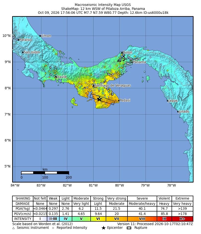
At 12:56 local time (17:56 UTC) on Friday 9 October 2026, a shallow earthquake struck beneath the Azuero Peninsula in central Panama. The USGS rates it Mww 7.7 and places the epicentre 12 km west-southwest of Pitaloza Arriba, at a depth of about 12.6 km. The number moved in the first hours: USGS first reported 8.0, then 7.6, before settling on 7.7. Panama's Instituto de Geociencias and SINAPROC use 7.5, after an early national figure of 7.2.
People across the country felt it, and USGS collected 1,969 felt reports. The USGS PAGER system, which estimates impact from models rather than field reports, gave a red alert for economic losses (1 to 20 percent of Panama's GDP) and a yellow alert for shaking-related deaths in the version cited on 9 October. Its levels changed between versions; the overall alert we use is orange.
Within minutes the US National Weather Service issued tsunami warnings for Panama, Colombia, Ecuador, Nicaragua and Guatemala. The US Tsunami Warning System later cancelled the alert for Panama's coasts, and no tsunami damage has been reported.
Damage and casualty figures
One death has been confirmed. Elena Barría, 68, of Macaracas in Los Santos, was seriously injured when a wall of her home collapsed. The Caja de Seguro Social confirmed on 14 October that she had died in hospital in Panama City, as Prensa Latina and others reported. From 9 to 13 October, authorities had reported no deaths.
SINAPROC has counted 27 people with minor injuries since 10 October, a figure unchanged in its 15 and 17 October reports: 17 in Coclé, 6 in Los Santos, 2 in Panamá Oeste, 1 in Herrera and 1 in Veraguas. No one has been officially reported missing.
The housing toll is much larger. The SINAPROC and Emergency Operations Centre report of 17 October (15:10), summarised by Eco TV Panamá, gave:
- 7,933 houses evaluated, with 26,018 people directly affected
- 1,952 houses with total damage, 4,857 with moderate or partial damage, 1,124 with light damage
- 3,827 people in 55 active shelters
- damage in ten provinces and the Ngäbe-Buglé comarca, with 74% of evaluated houses in Los Santos and Herrera
These counts have risen as assessors reach isolated villages. On 14 October SINAPROC listed 13,623 people affected and 3,696 in 45 shelters; its 15 October communiqué added 576 schools and 42 health centres affected. Another report of the 17 October data gives 27,017 affected, so the total is not settled.
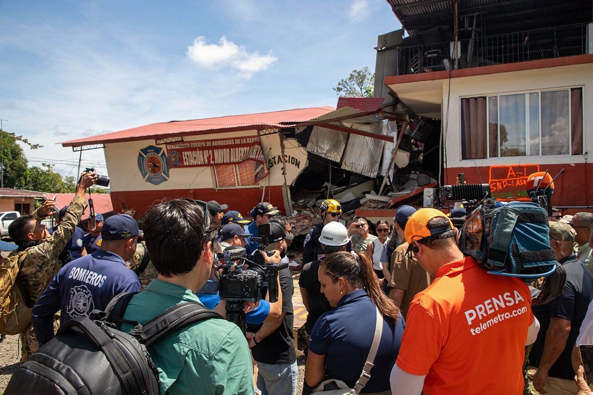
Local detail fills in the picture. As of 13 October, Herrera had 498 damaged homes, 32 landslides and 11 communities completely cut off. Veraguas had 614 damaged houses, widespread loss of power, water and internet, and more than 2,044 people in 16 shelters, mostly in Mariato. In Coclé, SINAPROC reported on 11 October 229 affected residences plus six hotels, 32 schools, 10 churches, 10 government buildings and a pedestrian bridge. Rescue workers inspected the San Juan Bautista Cathedral in Penonomé, and part of the tower of the Basílica Menor in Atalaya collapsed. CBS News reported large fissures along roads in Veraguas and no damage to Panama City's skyscrapers.
Why the Azuero Peninsula
Panama sits on a small block called the Panama microplate. To the northwest the Cocos plate subducts beneath it, to the southeast the Nazca plate does, and the right-lateral Panama Fracture Zone near 82°W separates the two. East of that fracture zone, the southern margin is seismically quiet and deforms mainly by sideways, strike-slip motion rather than subduction thrusting.
That motion is taken up by the South Panama Deformation Belt, with an estimated 20 to 25 mm per year of left-lateral movement. The Azuero-Soná fault is a major west-northwest trending splay of this belt that crosses the peninsula; a 2010 study cited by Hubbard and Bradley put its slip rate at 5 to 7 mm per year. The USGS moment tensor shows left-lateral strike-slip faulting, and the director of the Instituto de Geociencias attributed the quake to the Azuero-Soná system. Satellite radar analysis fits nearly pure strike-slip rupture on this fault between Tonosí and Mariato, possibly continuing onto an offshore segment. Because the rupture was shallow, shaking near it was severe, with a maximum intensity of MMI IX.
How it compares
This is described as the strongest earthquake in Panama since 1882 and the largest on-land earthquake in the country's recorded history. The 7 September 1882 event, estimated at Ms 7.9 to 8.3, struck offshore under the Caribbean near San Blas, raised a tsunami of about 3 m and killed around 250 people. Its magnitude is uncertain and it may have been larger than the 2026 quake.
The Azuero Peninsula itself had an M6.7 earthquake in 1913. Most other large regional events occurred near the Costa Rica border or on the Panama Fracture Zone: Ms 7.7 in 1934, M7.4 in 1991 (23 deaths) and Mw 6.2 to 6.5 at Burica in 2002. The USGS NEIC told Bloomberg this was the strongest quake in that part of Panama since at least 1951.
What our simulator shows
HazardSim treats the quake as a single point at 7.5868, -80.769 and draws circular intensity zones around it. The model counts 12,543 people in OpenStreetMap towns inside the intensity 8 zone (radius 47 km), 218,382 inside the intensity 7 zone (97 km) and 440,031 inside the intensity 6 zone (186 km). Its nearest towns are Llano de Piedra (24 km, intensity 8.8), Macaracas (29 km, 8.6), and Ocú, Pesé and Tonosí (40 to 41 km, about 8.2).
Those values sit close to the reported maximum of MMI IX, and Macaracas, high on the list, is where the one confirmed death occurred. The model is simplified, though. A magnitude 7.7 strike-slip rupture runs along a fault for tens of kilometres, here between Tonosí and Mariato, so places along that line can shake harder than their distance from the epicentre suggests. Mariato, where many Veraguas shelters are, is one example. The counts also include only mapped towns, not scattered rural homes, which make up much of the peninsula.
Aftershocks and the response
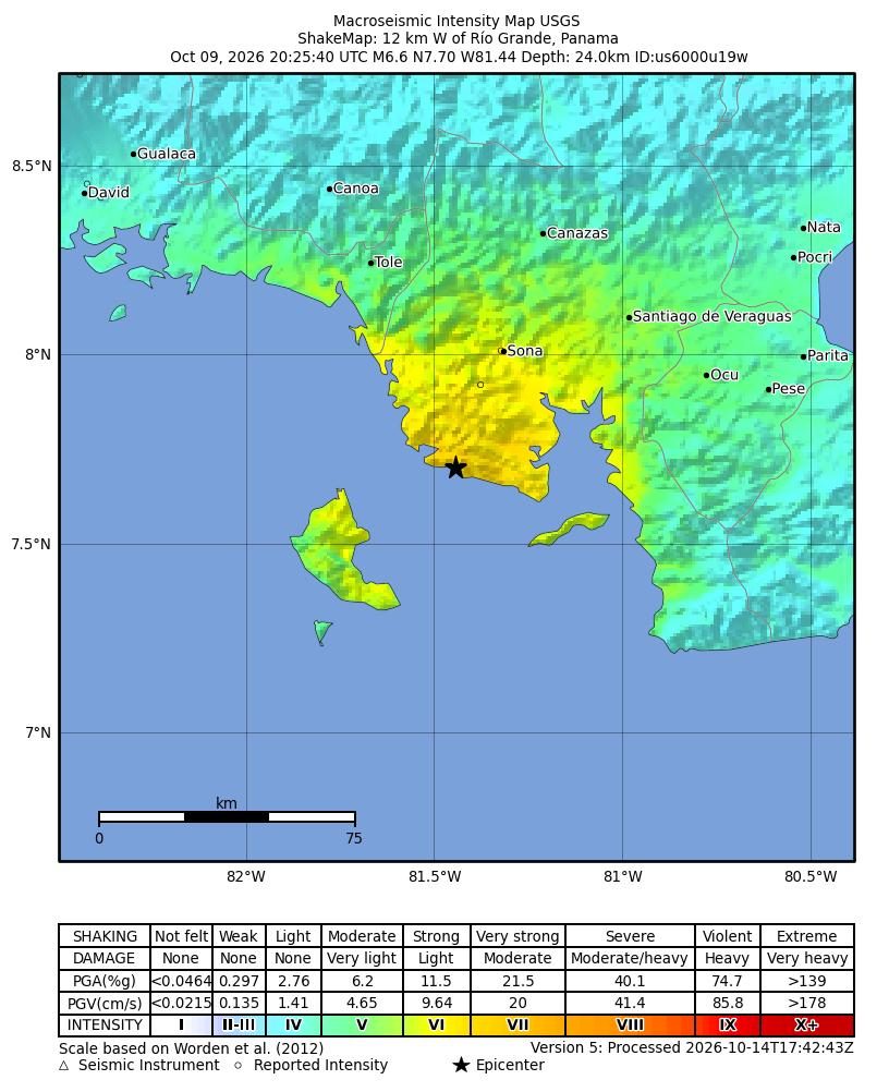
An M6.6 aftershock struck about two and a half hours after the mainshock, and USGS also listed an M5.8 near El Cacao. By the night of 9 October the Emergency Operations Centre director told CNN en Español that 147 aftershocks had been recorded. Hundreds more have followed.
The government declared a state of emergency on Saturday 10 October. On 16 October it reported 22,400 people and 6,800 families assisted, with 46 shelters open. Reporters described damaged bridges and roads blocking routes in central Panama, and on-scene video from Tonosí showed residents without water or electricity for more than a day as the ground kept moving.
Accounts from Penonomé describe the moment of shaking and the damage to buildings there.
What the simulator shows
The simulator turns magnitude and depth into shaking intensity on the Modified Mercalli scale. By that estimate about 440,031 people in towns listed in GeoNames were within 186 km of the epicentre, where intensity reaches VI and loose objects fall from shelves. Intensity VIII, strong enough to damage ordinary buildings, reaches about 47 km (12,543 people in towns).
| Town | Distance | Population | Intensity (model) |
|---|---|---|---|
| Llano de Piedra | 24 km | 1,054 | VIII |
| Macaracas | 29 km | 2,224 | VIII |
| Ocú | 40 km | 3,939 | VIII |
| Pesé | 40 km | 2,565 | VIII |
| Tonosí | 41 km | 1,478 | VIII |
| La Palma | 45 km | 1,283 | VIII |
| Llano Largo | 52 km | 1,013 | VII |
| Agua Buena | 49 km | 1,012 | VII |
This is a simplified model, not a damage report. Real effects depend on soil, buildings, terrain and the details of the event.
Open in the simulatorSources
- Official data: USGS
- GeoNames (CC BY 4.0): geonames.org
- USGS: M 7.7 - 12 km WSW of Pitaloza Arriba, Panama (event page)
- USGS: M 7.7 - 12 km WSW of Pitaloza Arriba, Panama (PAGER)
- Eco TV Panamá: Sismo en Panamá: 1,952 viviendas quedaron con daño total y 3,827 personas siguen en albergues
- SINAPROC: Comunicado Oficial #13
- Prensa Latina: Más de 13 mil personas afectadas y un fallecido por sismo en Panamá
- CNN en Español: Gobierno de Panamá declara estado de emergencia tras el fuerte sismo del viernes, que dejó al menos 27 heridos
- CNN en Español: Resumen de noticias del sismo en Panamá, del 9 de octubre de 2026
- Earthquake Insights (Hubbard & Bradley): Update on the M7.7 earthquake in Panama
- Al Jazeera: Panama earthquake: Tsunami warnings issued after magnitude 7.7 quake
- CBS News / AP: Panama struck by 2 powerful earthquakes, U.S. Geological Survey says
This review was compiled with AI assistance from the sources listed below and checked against official data.
More recent events
Click a point to open the event
 M6.0Magnitude 6.0 earthquake: Torres Islands region, Vanuatu
 M6.9Magnitude 6.9 earthquake: Kamchatka Peninsula, Russia
 269 km/hTyphoon Champi: Guam and Northern Mariana Islands
 M6.0Magnitude 6.0 earthquake: New Britain region, Papua New Guinea
 M6.8Magnitude 6.8 earthquake: Central Mid-Atlantic Ridge
 M6.7Magnitude 6.7 earthquake: Central Mid-Atlantic Ridge